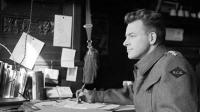
The British Columbia government has named a mountain in the Flathead region after Lieutenant Colonel Gerald Smedley Andrews C.M., M.B.E., O.B.C., B.Sc., D.Eng., C.M., P.Eng, F.R.G.S, BCLS, RPF (Ret’d). Gerald Andrews was a RCE WW2 veteran and B.C.’s longest-serving Surveyor General who died in 2005 at the age of 102 years.
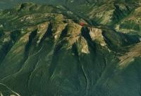
Mt. Gerry Andrews celebrates the Second World War veteran who served as British Columbia’s Surveyor General from 1951 to 1968 and who pioneered the use of aerial photography for mapping and forestry reconnaissance. The Flathead River region is an isolated watershed located east of the Rocky Mountain trench in the extreme southeastern corner of the province. At 2,205 metres, Mt. Gerry Andrews [latitude 49 11’32.6” N and longitude 114 33’ 33.5” W.] is the most prominent peak in the Trachyte Mountain Range.The citation for Gerald Andrews’ investiture into the Order of Canada summarizes his accomplishments:
One of our last explorers with a wealth of stories from his colourful life as a frontier teacher, farm and ranch hand, cook, horse wrangler, engineer and soldier, he was responsible for mapping some of the remaining uncharted wilderness areas of the interior of British Columbia. An expert in photogrammetry, as Surveyor General of British Columbia and Boundaries Commissioner, he contributed greatly to the geographical, economic and cultural development of his beloved province.
During WW II Major Andrews commanded the Canadian Air Survey Liaison Section that was responsible for coordinating the production of air camera units for the Canadian Army Overseas. His work was critical to the selection of the D-Day beaches in Normandy.
Born in Winnipeg, Manitoba, Gerald was a teacher at Big Bar Creek and Kelly Lake, BC (1922-26), obtained a Forestry Degree from the University of Toronto (1930), worked as Party Chief with the Surveys Division of the BC Forest Service (1930-39), and undertook postgraduate studies in aerial photogrammetry at Oxford and Dresden, Germany (1932-34).
With the onset of the Second World War, Gerry offered his extensive experience in aerial photography to the RCAF. After some rocky starts, his military service commenced with his being commissioned in the Royal Engineers. In July 1940, he was transferred to the Royal Canadian Engineers and assigned to 1 Canadian Corps Field Survey Company. Some years and promotions to Captain and Major followed along with widened responsibilities and continuation of a project to perfect a small size aerial camera. His work in this area resulted in his being elected Fellow of the RGS in October 1942.
In June 1943, General McNaughton assigned him to mobilize and command a Canadian Air Survey Liaison Section that would be responsible for finalizing specifications and to coordinate and monitor the production of air camera units for the Canadian Army Overseas. One of his greatest accomplishments involved preparations for Operation OVERLORD, the Invasion of Europe. There was a desperate need for detailed hydrography of approaches to the invasion beaches but they were occupied by the enemy. Using a method of correlating velocity of beach waves with depth of water and determining the wave velocity from consecutive timed air photos, Gerald’s unit computed and compiled more than 100 beach profiles - covering some 20 miles of beach that was centred on Arromanches.
After D-Day, his work with Beach Intelligence continued. Then, in May 1945, as Lieutenant Colonel, he was sent on a five-month solo mission to various war theatres to report on Military Survey, Air Photo Intelligence, and plans for post-war rehabilitation. He was demobilized in Vancouver, March 1946. With his return to British Columbia, he first served as Chief Air Survey Engineer for British Columbia and then laid the foundation for British Columbia’s mapping service as Surveyor General and Director of Surveys and Mapping (1951-68).
Upon retirement, Gerry undertook several short-term projects; one for the Federal Department of Energy, Mines and Resources and the other for Canadian International Development Agency (CIDA) He was a consultant to several countries and was involved with the Mekong River Study as well as teaching air photo interpretation to graduate engineers at the University of Paraiba, Brazil. In his 100th year, Gerald was featured in a special Remembrance Day Week exhibit at the Royal British Columbia Museum. Part of the display included his wartime intelligence photographs of pre-invasion Normandy beaches, aerial survey reports of then Major Andrews and his unit, 1943/44 mapping and other artifacts from his collection.
A keen historian who wrote prodigiously on matters related to history and surveying, he was active in the B.C. Historical Society and authored some 50 publications.
Gerry Andrews was the recipient of the Meritorious Achievement Award from the Association of Professional Engineers of B.C. and an Honorary Doctorate in Engineering from the University of Victoria 1988. He was also awarded the Centennial Medal, The Order of British Columbia (1990) and the Order of Canada (1991).
See also: Last Post Lt-Col Gerald Smedley Andrews


